
15 Epic Kananaskis Hikes for your Bucketlist!
When you think all the best hikes in the Canadian Rockies are around Banff National Park, get ready to change your perspective on that! After hiking the beautiful trails in Banff, we made our way to Kananaskis Country with our RV. And the abundance of epic hikes in Kananaskis blew us away! This part of Canada isn’t as popular as Banff or Jasper, but it does have some of the best hikes in the Canadian Rockies. Lace up your hiking boots and explore the best Kananaskis hikes.
15 MOST AMAZING KANANASKIS HIKES
Kananaskis Conservation Pass
To park at provincial parks and public use lands in the Kananaskis Country and Bow Valley region, a Conservation pass is mandatory. Two options are available for purchase: a daily pass or a yearly pass. Regardless of the number of passengers, only one pass per vehicle is needed. If you enter on foot, horse, or bike, there is no fee.
For additional details on the pass, including how and where to purchase it, visit the Kananaskis Conservation Pass website.
1. Smutwood Peak hike
Smutwood Peak hike was without a doubt one of our favorite hikes in Kananaskis and a huge adventure. The beginning of this hike is very easy through a stunning alpine meadow, but towards the summit, the elevation gain kicks in and doesn’t stop until you get to the true summit. Overall Smutwood Peak is a challenging hike but totally worth the effort.

The views throughout this hike are breathtaking, it really feels as if you’re amongst the giants of the Canadian Rockies. Smutwood Peak is definitely one of the most beautiful hiking trails we ever set foot on. In the alpine meadow you’re surrounded by several snow-capped mountain peaks. And once you start climbing Smuts Pass, you will soon see the picturesque Birdwood Lakes.


From here the steep incline to Smutwood Peak begins and the best views are coming the higher you get. The final push to the true summit involves a bit of easy scrambling but offers incredible views. You have 360 panoramic views at the top, so it’s definitely worth the extra effort if the weather circumstances allow you to get there.

Smutwood Peak hike is in prime Grizzly territory, so practice bear safety and be bear-aware during your hike. Grizzly Bears are often spotted along the trail, but don’t let this scare you away from the hike. As always, carry bear spray in bear country and know what to do and how to react in case of a bear encounter.
Read in our complete guide everything about Smutwood Peak hike
Distance: 17.9km (11.1 miles)
Elevation gain: 961m
Duration: 5 – 9 hours
Difficulty: Moderate-Difficult, mainly towards the summit.
Trailhead: Along Mount Shark Road just past Mount Engadine Lodge
2. Chester Lake hike
Chester Lake is one of the easy Kananaskis hikes and therefore a perfect family-friendly adventure. Located in Peter Lougheed Provincial Park, the Chester Lake Trail brings you to a stunning alpine lake surrounded by jagged peaks.
The 9.3-km out-and-back trail goes through dense pine and larch forests, along stunning alpine meadows and breathtaking mountain views once you approach Chester Lake. In autumn, the larch trees around the mountain lake transform into a vibrant golden-yellow color, making Chester Lake one of the best larch hikes in Kananaskis.
Read in our complete guide everything about Chester Lake hike
Distance: 9.3 km return / 5.8 miles return
Elevation gain: 315 m / 1,033 feet
Duration: 2-3 hours
Difficulty: Easy – Moderate
Trailhead: Chester Lake Trailhead along the Smith Dorrien Trail
Annual seasonal trail closure: From May 1 – June 29th Chester Lake Trail is closed to allow the trail to dry from snow and prevent damage

3. East End of Rundle Hike
The beautiful but challenging East End of Rundle Hike offers spectacular views of Ha Ling Peak, Bow Valley and Spray Valley. With the trailhead being closely located to downtown Canmore, EEOR hike (Eeyore as locals say) is a popular trail and a great day adventure for the experienced hiker. The technical terrain of EEOR trail includes very steep, rocky sections and scree slopes. And with only 3 kilometers one way to the summit at 2,545m (8,350 ft) height, you gain 880 meters of elevation. This means it’s a very steep trail from the beginning, so be prepared! Bring your hiking poles, plenty of water and of course proper hiking footwear.

If you prefer to hike a section of this trail then it’s possible as well. There is a stunning photo spot halfway up with breathtaking views of Ha Ling Peak. This will only take an hour to get there and is a stunning place for photography! At the East End of the Rundle summit you do have 360 views, but it’s mostly down into the valley with the mountain peaks further away.
Read in our complete guide everything about the East End of Rundle Hike

Distance: 5.6km (6.6 miles) out and back to the summit but about 3 km out and back to the photo spot
Elevation gain: 875 meters (2,871 feet) to the summit and around 400 meters to the photo spot
Duration: Between 3 and 6 hours
Difficulty: Moderate – Difficult
Trailhead: The EEOR trailhead might not be the most obvious. There are no signs pointing you in the right direction. But you have to keep your eyes out for the two power poles along the road where a worn trail takes you up EEOR. You can park your car at Whiteman’s Pond or at the main big parking lot of Ha Ling Peak trailhead.
4. Ha Ling Peak hike
Ha Ling Peak is a very popular hike in Kananaskis, closely located to Canmore. Therefore you can expect Ha Ling Peak to be a busy day hike. The 7.9 km (4.6-mile) round trip gains 750 meters on the way to the summit. This means it’s quite a steep hike but the trail is well-maintained with some steps and handrails in certain locations. The 360-degree views from the summit overlook the town of Canmore, the Rocky Mountains and Spray Valley. Because Ha Ling Peak is facing east, it is a great sunrise hike as it can also be easily accessed from the town of Canmore.
Distance: 7.9 km
Elevation gain: 750 meters
Duration: 3-5 hours
Difficulty: Moderate
Trailhead: Ha Ling Peak trailhead at Goat Creek Day Area

5. Grassi Lakes Hike
The Grassi Lakes are located on short distance from Canmore and the easy trail makes it a perfect family-friendly walk. The straightforward trail leads to two lakes with stunning crystal-clear turquoise-colored water.
Along the Grassi Lakes Trail, you are treated to diverse landscapes including lush forests, Ha Ling Peak views and cascading waterfalls. The highlight of the Grassi Lakes trail is undoubtedly the vibrant Grassi Lakes themselves, which are fed by glacier meltwater, giving them their distinctive hue. This is without a doubt one of the best easy hikes in Kananaskis, suitable for all skill levels.
Read in our complete guide everything about the Grassi Lakes Trail
Distance: 4 km roundtrip
Elevation gain: 125 meters (410 feet)
Duration: 1 – 2 hours
Difficulty: Easy
Trailhead: Grassi Lakes Trailhead is along Ken Ritchie Way

6. Yates Mountain (Prairie View Trail)
One of the ‘best bang for your buck’ hikes in Kananaskis is the one that goes up to a stunning viewpoint above Barrier Lake. This gentle hike that follows an old forestry road climbs gradually through the pine tree forest and takes up to a huge rocky ledge with spectacular views over Barrier Lake and Mount Baldy. This is a perfect spot to watch the sunrise or sunset, or have a lunch break. You can then extend the hike to Yates Mountain Summit, however, the best, open views are from the viewpoint.
Distance: 10.7 km until Prairie View,13.8 km full loop,
Elevation gain: 518meter until the viewpoint (880 meters to Yates Mountain summit)
Duration: 2-4 hours
Difficulty: Easy -Moderate
Trailhead: Barrier Dam parking lot on Highway 40 at Barrier Lake

7. Tent Ridge Horseshoe
The Tent Ridge Horseshoe hike is a beautiful but challenging 10-kilometer loop trail. The highlight of this amazing hike is the horseshoe-shaped ridge walk that offers 360-degree views of the surrounding mountains, including Mount Engadine, Mount Shark, and the Spray Lakes. Located in Spray Valley Provincial Park, the trailhead starts from the Mount Shark Day Use Area parking lot. Before embarking on this adventure, make sure to check trail conditions (little to no snow) as the ridge walk involves some scrambling over rocky terrain with steep drop-offs on either side.
Distance: 10.6km (6.6 miles)
Elevation gain: 850 meters (2,790 feet)
Duration: 4 – 6 hours
Difficulty: Moderate – Hard. Some short sections involve scrambling but nothing too serious. Go clockwise to scramble these sections up instead of down
Trailhead: Mount Shark Day Use Area parking lot

8. Wasootch Ridge Hike
The Wasootch Ridge Hike offers stunning views early on the trail with the highlight from the ridge’s summit. Sweeping vistas of the surrounding mountains, including the Kananaskis Valley and the peaks of the Canadian Rockies are awaiting you after a leg-burning climb through the dense forest,
The trail gradually gains elevation along the switchbacks up the mountainside. And as you ascend higher, the forest thins out, and the terrain becomes rockier. There are some steep sections with loose scree, so sturdy hiking boots and trekking poles are recommended for stability.
Once you reach the ridge, the trail levels out, and you’ll enjoy a relatively flat section as you traverse along the ridge. This part of the hike offers stunning views in all directions and is a great place to stop for a snack or to take photos.
The highlight of the Wasootch Ridge hike is the stunning panoramic views from the ridge’s summit. On a clear day, you are with expansive vistas of the surrounding mountains and valleys.
Distance: 15.4 km
Elevation gain: 1,450 meters
Duration: 5 – 8 hours
Difficulty: Moderate
Trailhead: Wasootch Creek parking lot

9. Pocaterra Ridge
The Pocaterra Ridge trail is located near Highwood Pass in Kananaskis and is a point-to-point hike. Therefore it is best done with two cars which you can park at the beginning and end point. However, if you have one car you can still easily get amazing views, just follow the South Pocaterra Ridge and turn around at the Pocaterra Ridge summit.
Pocaterra Ridge trail is a fantastic larch tree hike with a valley covered by these stunning trees. In fact, it is one of the, if not the best, Larch tree hike in Alberta. So make sure to put this Kananaskis hike on your list when you’re there in autumn!
Distance: 9.3 km until the summit turnaround, 11.4km point-to-point
Elevation gain: 745 meters out and back to the summit, 764 meters point-to-point
Duration: 4 – 7 hours
Difficulty: Moderate
Trailhead: Highwood Meadows Trail

10. Sarrail Ridge and Rawson Lake hike
Sarrail Ridge is an epic adventure in Kananaskis leading up to the ridge under Mount Sarrail with breathtaking panoramic views of Upper Kananaskis Lake, Mount Indefatigable, Mount Lyautey, and other surrounding peaks.

Initially, you follow the Rawson Lake trail which is a great spot for a break before the trail branches off into the forest where the hard work begins. As you ascend, the trail switchbacks up the mountainside, offering occasional glimpses of the lake below. The terrain becomes rockier with some short scramble sections as you near the ridge.
The highlight of the wonderful hike to Sarrail Ridge is the breathtaking panoramic views from the ridge’s summit. After the steep climb you are rewarded with sweeping vistas of Upper Kananaskis Lake, Mount Indefatigable, Mount Lyautey, and other surrounding peaks.
Distance: 12.2 km round trip
Elevation gain: 1,066m
Duration: 4 – 5 hours
Difficulty: Hard
Trailhead: Upper Kananaskis Lake Day Use Area

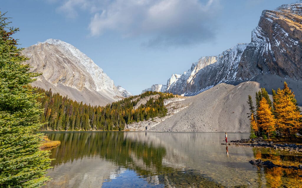
11. Lilian Lake & Galatea Lakes hike
The Lilian Lake & Galatea Lakes hike takes you to three enchanting alpine lakes surrounded by towering rugged peaks. This moderate hike winds through dense forest, along lush alpine meadows, crossing several creeks and offering occasional views of the surrounding mountains on the way to Lillian Lake. This part is 6 kilometers (3.7 miles) one way, with an elevation gain of about 576 meters (1,893 feet).

Continuing past Lillian Lake, the trail leads to the Galatea Lakes. The total distance to reach the upper Galatea Lake is 8 kilometers (5 miles) from the trailhead, with a total elevation gain of about 837 meters (2,749 feet).
Distance: 12 km to Lillian and 16.4 km to Galatea
Elevation gain: 576 meters to Lillian and 837m to Galatea
Duration: 4 – 7 hours
Difficulty: Moderate
Trailhead: Galatea Day Use Area

12. Ptarmigan Cirque Hike
The Ptarmigan Cirque trail is a short hike of 4 kilometers (2.5 miles) round trip. Therefore it is a great hike for families with stunning views along the way. The highlight of the Ptarmigan Cirque hike is the breathtaking alpine cirque, a natural amphitheater surrounded by towering peaks. You can hike the Ptarmigan Cirque trail year-round, but the trail is in particular beautiful in late summer with wildflowers and in autumn with golden larch trees. Furthermore, the landscape features lush meadows, beautiful mountain views, and cascading waterfalls. You even might see bighorn sheep along the trail!
Distance: 4 kilometers (2.5 miles) loop hike
Elevation gain: 290 meters (951 feet)
Duration: 2 hours
Difficulty: Easy
Trailhead: Highwood Pass area along Highway 40 in Peter Lougheed Provincial Park

13. Black Prince Cirque
The 4 km Black Prince Cirque hike is another fantastic Kananaskis trail. The fairly easy hike follows a well-marked path through dense forest before emerging into the open alpine meadows of the cirque. In this natural amphitheater, you are surrounded by rugged peaks where you can have a break at the small alpine lake. The great thing is that this hike is accessible year-round. You can easily hike this trail in winter when the snow is packed.
Dogs are allowed on the Black Prince Cirque trail but must be kept on a leash at all times as there are mountain goats living in the area. It’s also essential to carry bear spray and know how to use it, as this is the habitat for black bears and grizzly bears.
The trail is closely located to the Blackshale Creek Suspension Bridge which is definitely worth a visit as well!
Distance: 4 km (2.5 miles)
Elevation gain: 158 meters (521 ft)
Duration: 1 – 2 hours
Difficulty: Easy year-round hike
Trailhead: Along the Smith-Dorrien/Spray Trail (Highway 742) near the Kananaskis Lakes area

14. Grizzly Peak Trail
Although the views at the summit of Grizzly Peak are outstanding, the uphill battle along loose scree is exhausting. This is not a beginner hike and to be honest, there are some better options in this list with the same kind of, and even better views. However, if you’ve done them all, then Grizzly Peak Trail is definitely a fun challenge. At the summit, you’ll have endless views over Kananaskis Valley and the Lower Kananaskis Lakes.
Distance: 6.8 km
Elevation gain: 875 meters
Duration: 4 – 6 hours
Difficulty: Hard
Trailhead: There is no official parking area, so park safely along the side of the road near Ripple Rock Creek.

15. Troll Falls hike
Troll Falls hike is another short but sweet all-season hike. Along the trail, you will pass a grove of aspens and follow a well-maintained trail through stunning forest. Although the waterfall isn’t the most spectacular of all Alberta waterfalls, the lovely short hike makes it a great family-friendly activity in Kananaskis.
Distance: 3.4 km round-trip
Elevation gain: 30 meters (98 feet)
Duration: 1 – 2 hours
Difficulty: Easy
Trailhead: Troll Falls parking lot

What is the best time for the Kananaskis hikes?
The best time for hiking in Kananaskis is during the summer months from July until August and early fall in September. If snowfall comes late in the season, then you can even hike safely until early-mid October.
Early June marks the beginning of the hiking season in Kananaskis, with trails starting to thaw from winter snowpack. While some trails may still have lingering snow and muddy sections, it’s a great time to beat the crowds and enjoy the tranquility of the mountains before the peak summer season.
Late September brings stunning fall foliage, with golden hues painting the landscape, offering a picturesque backdrop for hiking adventures. The weather tends to be cooler and more unpredictable, so it’s essential to dress in layers and be prepared for changing conditions. If snow comes early season, then you can’t safely access the higher peak hikes anymore. Unless you have avalanche experience and the right gear.
Where to stay in Kananaskis?
Kananaskis Mountain Lodge – Autograph Collection
Kananaskis Mountain Lodge is a beautiful 4-star resort nestled in the mountains. With 5 on-site restaurants, a full-service spa, an indoor heated pool and stunning walking trails right outside of the property, Kananaskis Mountain Lodge is the perfect place to unwind after a day of exploring. We loved the spacious and cozy rooms, extensive breakfast and free S’mores by the campfire at night!
→ Check here current prices and availability for Kananaskis Mountain Lodge


Mount Engadine Lodge in Spray Valley Provincial Park
Mount Engadine Lodge is the only accommodation in Spray Valley Provincial Park. Surrounded by breathtaking mountain peaks, this is truly a unique, off-the-beaten-path stay. With all the best Kananaskis hikes at your doorstep, staying at Mount Engadine Lodge provides you with plenty of outdoor activities. With their onsite bar and restaurant and all-inclusive meals, you don’t have to worry about anything else after booking your mountain view room or glamping tent at Mount Engadine Lodge.
→ Check here current prices and availability for Mount Engadine Lodge

Is Kananaskis a National Park?
No, Kananaskis Country is not a National Park. It is a sprawling recreational area located in the Canadian Rockies of Alberta, Canada. Kananaskis Country encompasses over 4,000 square kilometers (1,544 square miles) of pristine wilderness, including mountains, forests, rivers, and alpine meadows.
While it is not a National Park, Kananaskis Country is managed by the Government of Alberta’s Ministry of Environment and Parks. It is divided into several provincial parks, recreation areas, and wildland provincial parks, each offering a wide range of outdoor activities such as hiking, camping, fishing, skiing, and wildlife viewing.
Some of the well-known parks and areas within Kananaskis Country include Peter Lougheed Provincial Park, Spray Valley Provincial Park, Bow Valley Provincial Park, and Elbow-Sheep Wildland Provincial Park. Despite not being a National Park, Kananaskis Country is beloved by outdoor enthusiasts for its stunning scenery, abundant recreational opportunities, and accessibility from nearby cities such as Calgary and Canmore.
What is the easiest summit in Kananaskis?
One of the easiest summits to reach in Kananaskis Country is Ha Ling Peak. The 7.5 kilometers (4.7 miles) round trip, with an elevation gain of about 700 meters (2,297 feet) is steep in sections, but also well-maintained and relatively straightforward, making it suitable for hikers of all skill levels.
More Canada travel inspiration
I hope you enjoyed this complete guide about the best Kananaskis hikes. For more travel inspiration about Alberta and British Columbia, head over to our other Canada travel guides. See below our Canada guides per National Park and area for more travel inspiration.
Read here our incredibly extensive guide about RVing in Canada

Kananaskis
Grassi Lakes hike – The Complete Guide
Smutwood Peak hike – Complete Guide
East End of the Rundle hike – Complete Guide
Banff National Park
25 best and easy hikes in Banff – Ultimate Guide
Larch Valley hike – Complete Hiking Guide
Spectacular Peyto Lake – Complete Guide
Plain of the Six Glaciers Trail – Complete Hiking Guide
Johnston Canyon Hike – Complete Guide
Vista Lake walk – Complete Guide
Parker Ridge Trail – Complete Hiking Guide
Horse riding experience in Banff National Park
Jasper National Park
Mount Edith Cavell hike – The Complete Guide
Kootenay National Park
Floe Lake hike – Complete Guide
British Columbia
How to hike the epic Panorama Ridge in Garibaldi Provincial Park
Joffre Lakes hike – Complete Hiking Guide
St Marks Summit hike Vancouver
The best Whale Watching tours in Vancouver
Stunning Helmcken Falls in Wells Gray Park
Did you find this post useful? Save THIS PIN to your Pinterest board on Pinterest to read it later again.


This post may contain affiliate links
We hope this guide will help you plan your travels! If you consider booking your accommodation, tours or rental car via our affiliate links, you support this blog because we earn a small commission at no additional cost to you!