Beautiful St Marks Summit hike – Epic view of Howe Sound
The St Marks summit hike near Vancouver is a fantastic 11-kilometer round trip, taking you to a panoramic viewpoint overlooking Howe Sound, the Gulf Islands and surrounding mountains. Located in Cypress Provincial Park, you can reach the trailhead in under 30 minutes from downtown Vancouver. Saint Marks summit trail ascends through a lush forest while gradually gaining elevation and takes around 4-5 hours to complete. It is one of the best hikes in Vancouver and is in particular a great spot to watch sunset. If you are looking to add some more kilometers, then you can also extend the St Marks summit hike as it is part of the 29-kilometer (18 miles) long Howe Sound Crest Trail. In this complete guide, we will share all you need to know about St Marks summit hike so you’re well prepared!
St Marks summit hike statistics
Length: 10.5 km
Elevation gain: 590 meters
Duration: 4 – 5 hours
Difficulty: Moderately. This is not a technical hike
Facilities: Toilets at the trailhead
Where is St Marks summit?
Saint Mark’s Summit is located in Cypress Provincial Park, which is part of the Coast Mountain Range in British Columbia, Canada. The trailhead for the St. Mark’s Summit hike is at Cypress Mountain Ski Area, situated north of Vancouver.
How to get to St Marks summit trailhead?
The trail for St Marks summit starts from Cypress Mountain ski area and is best accessible by car. In case you’re visiting Vancouver, the best way to get to the trailhead is with a rental car. If you’re a BC resident you can use a car sharing app such as EVO or Modo.
The get to the trailhead from the carpark, walk passed the Cypress Creek Lodge where you see the Olympic rings. Walk further past the lodge and chairlift until you come at a junction with orange markers. Here you will see green signs of Howe Sound Crest Trail and Bowen Lookout marked with square, orange markers. The trail veers into the forest and passes along the ski run until you reach a junction with a large green water tower. Here you can choose both the Howe Sound Crest Trail West or Howe Sound Crest Trail East because they join again after a little while.


To make sure you stay on the right trail I highly recommend always downloading the offline hiking map on Alltrails.
Where to park for St Marks summit?
There is a huge parking lot at Cypress Creek Day Lodge where you can park for free. If all spots are taken then there are several large overflow parking areas along the road.
If you are planning to hike St Marks summit for sunset, then you need to be aware that the gate of the official Cypress Mountain ski car park shuts overnight. Therefore I advise to park outside of the gates. This is just a couple of meters further away from the main parking. If you plan to go camping at St Marks Summit, then you have to use parking lot 3B which is the only one that allows overnight parking.
Saint Marks summit trail directions
The first 2 kilometers of St Marks summit trail is along a wide, gravel road that leads up into the forest. At the 2-kilometre mark, you will reach a fork in the trail with a side trail leading to Bowen Lookout. This trail adds another 1.7 km out and back and offers nice views. However, because you’re not above the tree line yet at this point, the view from Bowen Lookout is still a but obstructed by towering trees. Therefore I would recommend carrying on and going for the breathtaking view at St Marks summit.

From the 2-kilometre mark the trail continues to climb steadily uphill with lots of switchbacks. The gravel road ends and continues into the forest on a dirt path where you will have to navigate over some tree roots and rocks. Although the terrain gets a bit more technical, you don’t have to worry that it gets too difficult.


The last part of the trail is a combination of wooden stairs and a forest path before you get to the swampy ground. Luckily there are wooden planks that help you to navigate over this part without having to make your shoes too dirty.

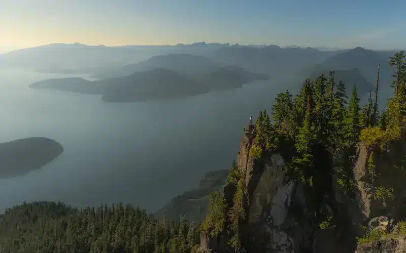
After this part you’re almost there! You will soon see a sign that marks the summit, but to get to the actual viewpoint you have to scramble up the rocks on your left side. This is the first viewpoint from where you can enjoy the breathtaking scenery of Howe Sound, the Tantalus Range and even Vancouver Island! At this spot there are plenty of curious squirrels. And although they look so cute, make sure to not give them human food as they can die from it.


In our opinion this first viewpoint is not the best, at least for photography it isn’t because some bushes are obstructing the view. But if you look at the right side, you’ll notice a rocky outcrop. This is a fantastic photo spot if you dare to sit or stand on the rock. The photographer needs to stay at the first viewpoint though to get the best angle. And a zoom lens or super wide lens would be the best option to go for.


This second viewpoint also offers a different perspective and better views on Horseshoe Bay and the Sea to Sky Highway. So even is you’re not into photography, it is worth it to check out the second viewpoint as well.
As mentioned earlier in the introduction, the trail doesn’t end at St Mark’s Summit. It is part of the 29-kilometer (18 miles) long Howe Sound Crest Trail which spans from Cypress Bowl to Porteau Cove. So if you are down for an extended version, then you can continue along this trail to the so-called Unnecessary Mountain or The Lions. I would love to hike this trail, maybe next time when I can stay longer in Canada on a working holiday visum!
How long does it take to hike St Marks summit?
St Marks summit hike time is around 4 to 5 hours to complete. The total time can vary based on individual hiking speed, fitness level, and the amount of time spent enjoying the viewpoints along the trail. If you’re planning to add Bowen Lookout as a side trip, then you should allow 30 – 45 minutes extra.
Is St Marks summit hard?
I rate St Marks summit hike moderately as the trail isn’t too hard to follow and well maintained. The elevation gain of Saint Marks summit hike is 590 meters over 5 kilometres which isn’t too bad. If you have hiking poles I highly recommend to bring them. Although the trail is a gradual incline all the way until the summit, it’s always nice to have that bit of extra support.
What is the best time to hike St Marks summit?
The best season to hike St. Marks summit is late spring, summer and fall. In general the trail is accessible when the snow has melted in either late May or early June until the first snowfall in November.
If you plan on hiking St Mark summit in the summer months, then be prepared for crowds and mosquitoes. The trail is very popular and will be crowded during the weekends. Therefore try to go on a weekday early morning or late afternoon to catch sunset at the summit.
The best time of the day to hike St Marks trail depends a bit per season. In general I always advice to start your hike early to beat the crowds. However, St Marks summit with sunset is truly magical. Facing west, you will have an incredible vantage point at the summit, and the golden light is absolutely magical and provides epic photo opportunities.

Can you hike St Marks summit in winter?
Yes, you can go snowshoe hiking to St Marks summit in winter. If you’re experienced with snowshoe hiking and the trail you can rent snow shoes from Cypress Mountain Hollyburn Nordic Centre. However, people have died on St Marks summit trail in the winter because they got lost along the track. Therefore I highly recommend to book this guided snowshoe hiking tour which is included with equipment, a professional guide and transport. Just make sure to wear appropriate warm and waterproof winter clothing because snow that melts on your pants gets really cold!
Do you need a St Marks summit hike day pass?
No, there are no requirements for a day pass to hike in Cypress Provincial Park. On the website of BC Parks you can find the current BC parks that require a day pass.
Is it allowed to go camping at St Marks summit?
There are no camp facilities nor official camp spots at St Marks summit, but regulations and policies can change. Therefore it’s crucial to check with the relevant local authorities such as BC Parks or Cypress Mountain Resort. Additionally, always practice responsible camping and adhere to Leave No Trace principles to minimize your environmental impact. This also counts for hikers, pack in what you pack out to keep nature clean for wildlife and future generations.
Wildlife at St Marks summit
Situated in Cypress Provincial Park, the diverse natural environment is present of small and big wildlife. You’re in bear country and black bears live in the park. So always be prepared and know what to do when you encounter a bear in Canada. Carry bear spray, know how to use it and what to do in the event of a bear encounter.
The only wildlife we saw at St Marks summit were curious squirrels and the blue Steller’s Jay bird. Please be aware that although these animals will approach you, don’t feed them as human food can kill wildlife.


Is St Mark Summit dog-friendly?
Yes! You can bring your dog to St Mark Summit but they must be kept on a leash.
Where to stay near St. Marks summit hike
- West Vancouver: This is the closest urban area to Cypress Mountain. You can find all sorts of hotels, motels, and bed and breakfasts in West Vancouver.
- North Vancouver: Located just across the Burrard Inlet from West Vancouver, North Vancouver also offers a variety of accommodation options.
- Downtown Vancouver: If you don’t mind a bit of a drive, downtown Vancouver provides a wide range of hotels for all budgets. It’s well-connected to the highway leading to Cypress Mountain.
- Squamish: A bit farther north, Squamish is a popular outdoor recreation destination. It’s about a 45-minute drive from Cypress Mountain and offers various accommodation choices.
More Canada travel inspiration
I hope you enjoyed this complete guide about St. Marks summit hike near Vancouver. For more travel inspiration of Vancouver, British Columbia and Alberta, head over to our other Canada travel guides.


This post may contain affiliate links
We hope this guide will help you plan your travels! If you consider booking your accommodation, tours or rental car via our affiliate links, you support this blog because we earn a small commission at no additional cost to you!