Complete Guide to Smutwood Peak Hike in Kananaskis Canada
It was a cold autumn night when we hiked Smutwood Peak for sunrise. Frost on the grass twinkled in the light of our headlamps and looked like little diamonds while we made our way deeper into the valley. The towering snow-capped peaks lit up from the moonlight. It was just us under a sky full of stars, the moon, and the mountains. We were perfectly in time at Smutwood Peak to catch the first light. A moment that left us in awe, realizing how small we are in an infinite world of beauty and possibilities.
Smutwood Peak in Kananaskis country is one of those hikes that will always stay with us. Because we realized again during this hike that it’s not about the destination, but the journey. I highly, highly recommend adding this awesome Kananaskis hike to your itinerary and will share everything you need to know about Smutwood Peak hike in this complete guide.
Smutwood Peak Hike statistics
Length: 17.9 km / 11.1 miles
Elevation gain: 998 meters.
Smutwood Peak height: 2,699 meters (8,856 feet)
Duration: 5 – 9 hours.
Difficulty: Moderately in the first 7 km, but it’s getting a bit more difficult with some scramble towards the summit.
Facilities: There is no toilet at the trailhead. Neither there is cell service in the area or any other facilities to buy food or water. So make sure to come very prepared! Download the map offline so you can always check if you’re on the right track.

Where is Mount Smutwood?
Mount Smutwood is situated in Kananaskis Alberta province in the beautiful Spray Valley Provincial Park. This park is part of the Kananaskis Country Park system along with many other parks such as Bow Valley Provincial Park, Peter Lougheed Provincial Park, and many more.
The funny thing about Mount Smutwood’s name is that it is a mix of two mountain names. Because Mount Smutwood sits between Mount Smuts and Mount Birdwood it got the merged name Mount Smutwood.
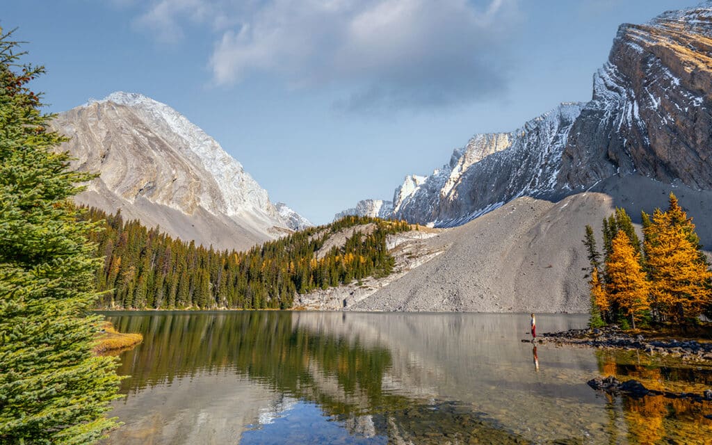
You have probably seen pictures of Smutwood Peak hike facing a beautiful, sharp peak with two lakes at the bottom. This is Mount Birdwood and the two lakes are called Birdwood Lakes, which are the center of attention for a photo at the summit of Smutwood Peak.

How to get to Smutwood Peak Trailhead
The Smutwood Peak trail begins along an unnamed road close to Mount Engadine Lodge. Some people refer to this road as Mount Shard road, but Google Maps won’t recognize this name. To get to the Smutwood Peak parking, you first follow the unpaved Smith-Dorrien Road until there is a turn-off that goes to Mount Engadine Lodge. Smutwood Peak trailhead is right around the corner on the left-hand. You can easily drive here with a normal car, so no 4×4 car is needed. Smutwood Peak trailhead is on Google Maps so you can just follow the navigation and you will soon enough see the parking.


How long does it take to hike Mount Smutwood Peak?
With 17.9km (11.1 miles) out and back and an elevation gain of almost 1000 meters Smutwood Peak hike will take you anywhere between 5 and 9 hours. It just depends on how quick you are, how much time you take at the summit, and how many breaks you need along the way.
While the first couple of kilometers are easy without much incline, the more challenging part comes later in the hike and involves a bit of scrambling toward the summit.

Best time to hike Smutwood Peak Kananaskis
Smutwood Peak hike can only be attempted in a short window of time due to the high elevation and chance of snow along the trail. The best months to hike Smutwood Peak is between the end of June when most snow has melted onwards to the first snowfall in October.
If you do have experience hiking in a snowy alpine environment and you have the right equipment, then Smutwood Peak can also be tackled outside of these months. However, the hike will feel much heavier because hiking in snow is pretty exhausting. Especially with the incline, you’ll get towards the summit.
We hiked Smutwood Peak for sunrise in the second week of October and the trail was still very well accessible. Of course, this depends on how early snowfall comes. So make sure to do your research before attempting the hike. Read recent reviews on AllTrails on the trail conditions and check the weather forecast before planning the hike.
If you love autumn foliage then planning this hike in late September until early October is a great choice. There are some larch trees along Smutwood Peak hike which gives the landscape a mesmerising touch.

Smutwood Peak trail description
Smutwood Peak trail begins along an old logging road and partly through the forest before the path merges along Commonwealth Creek. As you approach the 2 km mark you can admire a stunning waterfall surrounded by beautiful mossy rocks and lush forest. It’s worth a quick stop on the way in, or out.


The trail keeps following the creek until you get to a beautiful open and vast alpine meadow. Here you are surrounded by mountain peaks. It’s extremely beautiful. Everywhere you look are towering mountains. Seriously breathtaking, we couldn’t stop looking around when we made our way back in daylight after hiking this part in the dark on the way in.


Smutwood Pass incline
While you make your way further into the valley the ascent towards Smutwood Pass will appear. At approximately 5km into the hike, the elevation gain to Smutwood Peak will begin with a section of steep switchbacks up the pass. Here it is important to keep the avalanche debris on your left side and not make your way up this slippery slope.
For about 2 km the incline is going to be relentless but then lightens up a bit. From here on the views on Mount Birdwood on your left side and Birdwood Lakes on your right side will become better and better. The trail then cuts into the scree slopes above Birdwood Lakes and takes another 1.5 km and about one hour to the true summit of Smutwood Peak.


The technical part of the hike
From here on the more technical section begins. There is a lot of loose rock here but the trail is well padded down so you can easily see the route. So although this is totally doable for most experienced hikers, caution is advised along this part. Depending on the season you might see some snow here on the trail. This side of the mountain is facing west and gets little sunshine throughout the day.


The views of Mount Birdwood and Birdwood Lakes are getting better the higher you get. But with higher elevations, the wind can pick up as well. This was the case for us, the wind was so cold and sharp that it hurt our faces, even with a hoodie on.

From the false summit at the 8.5 km mark, you will already have an impressive view of Mount Birdwood and the two lakes below. While this is not the true summit, you can decide here if you want to push through or enjoy the views from this spot.

The final part to the summit is a true scramble and very exposed. The technicality of this part of the scramble can be listed as a class 2 if you are familiar with the different scramble levels. With the heavy wind that we had, we decided to not risk it to the true summit. We were already hiking since 4 AM and our goal was to shoot sunrise and get back safely to our camper truck. Mission accomplished and an adventure we will never forget!

What to prepare before hiking Smutwood Peak
There are a few important things you need to know before hiking Smutwood Peak. These preparations also apply for other hikes in Kananaskis, or the Canadian Rockies in general.
- Download the offline map for this particular hike. We use AllTrails and it’s mostly very accurate. There is no cell service in the park.
- Carry bear spray and know how to use it. Educate yourself on what to do and how to act in case of a bear encounter. The behavior of black bears and grizzly bears can differ, so please educate yourself and know what to do!
- Buy a Conservation Pass which is required to park at provincial parks and public use lands in the Kananaskis Country. You don’t need a National Park pass in Kananaskis.
- Bring your hiking poles, you need them.
- No campfires are permitted along the trail.
- Pack in what you pack out. Practice the Leave No Trace principles.
- Bring enough water, food, and snacks. It’s going to be a long day.
- Check the Smutwood Peak trail conditions and recent reviews on the AllTrails app to see what other hikers say. This is in particular good to know if there were recent bear sightings.

Wildlife at Smutwood Peak Kananaskis
If you’re like us, visiting Canada as a traveler and outdoor lover, you might be new to bear country. Please be aware that Kananaskis is prime grizzly territory. This is not to scare you but to make you very aware of the wildlife that can be around. There are frequent sightings of black bears, grizzly bears, moose, coyotes, and cougars in this region.
While these wild animals are mostly in a calm state of mind, they will feel easily threatened by humans in case they have offspring around. Or when a human comes too close, either to their food source or accidentally startles the animal. Therefore you should be very aware of your surroundings during the hike and make noise so an animal can hear you coming.
We didn’t see any bears while hiking Smutwood Peak. As I wrote before, we hiked in the dark to get to Smutwood Summit for sunrise. Of course, it was a little bit scary, but we were very well prepared. We carried bear spray, we knew what to do in case of a black bear or a grizzly encounter. We educated ourselves and read plenty of articles about this. Because both bears are completely different animals, they need a different approach in case of an encounter. Please be bear aware and do your research!
While hiking we made noise with our hiking poles and kept talking to each other throughout the hike (also to comfort the nerves a bit hehe). We didn’t stop in the dark on the way to the summit, this would have been different when it would have been during the day. Some other bloggers wrote that they did see a grizzly above the tree line and near the lakes. It seems there is a den around, so make sure to always keep observing your surroundings. As soon as you’re out of the forest there is plenty of open space to look into the distance. The alpine meadow as well as Smutwood Pass are very open, so you can look 360 degrees around.
Conservation Pass in Kananaskis
To park at provincial parks and public use lands in the Kananaskis Country, a Conservation pass is mandatory. Two options are available for purchase: a daily pass or a yearly pass. Regardless of the number of passengers, only one pass per vehicle is needed. If you enter on foot, horse, or bike, there is no fee.
For additional details on the pass, including how and where to purchase it, visit the Kananaskis Conservation Pass website.
Other amazing Kananaskis hikes
There are plenty of other amazing hikes in Kananaskis Country Provincial Park. We did quite some research and can recommend the following epic hikes.
East End of Rundle
East End of Rundle hike offers spectacular views of Ha Ling Peak, Bow Valley and Spray Valley. With the trailhead being closely located to downtown Canmore, EEOR hike (Eeyore as locals say) is a great day adventure for the experienced hiker. The technical terrain of EEOR trail includes very steep, rocky sections and scree slopes. And with only 3 kilometer one way to the summit at 2,545m (8,350 ft) height, you gain 880 meters of elevation. But, you can also choose to only go to the photo spot with the best views on Ha Ling Peak, where you can get in less than an hour hiking. In that way, the East End of Rundle is a short hike with a huge reward.
Read in our complete guide all the details about East End of Rundle hike

Chester Lake
Chester Lake is a 9 km (5.8-mile) return hike following a wide gravel track through the forest which opens up in a beautiful alpine meadow that leads to the lake. With only 315 meters (1,033 feet) elevation gain it is a perfect family-friendly Kananaskis hike. The picturesque alpine basin of Chester Lake reflects the rugged beauty of the mountains that surround it which makes it a perfect place to relax and capture amazing landscape photos. The area around the lake is big and offers plenty of space for people to sit down and picnic. Remember, pack in what you pack out.
Read in our complete guide everything about Chester Lake hike Kananaskis
Ha Ling Peak
Ha Ling Peak is the most popular hike of Kananaskis and is closely located to Canmore. Therefore you can expect Ha Ling Peak to be a busy day hike. The 7.8 km (4.6-mile) round trip gains 750 meters on the way to the summit. This means it’s quite a strenuous hike. The 360-degree views from the summit overlook the town of Canmore, the Rocky Mountains and Spray Valley. Because Ha Ling Peak is facing east, it is a great sunrise hike as it can also be easily accessed from the town of Canmore.
Where to stay near Smutwood Peak Trail
Right around the corner of Smutwood Peak Trailhead is Mount Engadine Lodge located. This is the only accommodation inside Spray Valley Provincial Park and the perfect option if you want to do more hikes in Kananaskis.
The nearest town to Smutwood Peak is Canmore located on an hour’s drive. It offers a range of facilities and accommodation choices, making it the most convenient option. However, one drawback we experienced during our stay in Canmore was the persistent sound of train horns echoing throughout the town, both day and night. We stayed at Coast Canmore Hotel which was very good.
For a more quiet and off-the-beaten-path experience, I highly recommend Kananaskis Village which is only 50 minutes away from Chester Lake. We stayed in Kananaskis Mountain Lodge which is a stunning luxury accommodation with beautiful rooms. The only downside is that this village doesn’t have as many facilities as Canmore. But it’s a fantastic quiet stay.
Coast Canmore Hotel
The spacious and newly refurbished rooms of Coast Canmore have stunning views of the surrounding mountains. With comfy big beds, it is the perfect place to relax after a day of exploring. With an on-site restaurant and bar, indoor pool and meeting rooms, Coast Canmore has a great price-quality ratio.
We really enjoyed staying in Coast Canmore Hotel, especially the views on Ha Ling Peak from bed!
→ Check here current availability and prices for Coast Canmore

Kananaskis Mountain Lodge – Autograph Collection
Kananaskis Mountain Lodge is a beautiful 4-star resort nestled in the mountains. With 5 on-site restaurants, a full-service spa, an indoor heated pool and stunning walking trails right outside of the property, Kananaskis Mountain Lodge is the perfect place to unwind after a day of exploring. We loved the spacious and cozy rooms, extensive breakfast and free S’mores by the campfire at night!
→ Check here current prices and availability for Kananaskis Mountain Lodge


Mount Engadine Lodge in Spray Valley Provincial Park
Mount Engadine Lodge is the only accommodation in Spray Valley Provincial Park. Surrounded by breathtaking mountain peaks, this is truly a unique, off-the-beaten-path stay. With all the best Kananaskis hikes at your doorstep, staying at Mount Engadine Lodge provides you with plenty of outdoor activities. With their onsite bar and restaurant and all-inclusive meals, you don’t have to worry about anything else after booking your mountain view room or glamping tent at Mount Engadine Lodge.
→ Check here current prices and availability for Mount Engadine Lodge

More Canada travel inspiration
I hope you enjoyed this complete guide about the Larch Valley hike in Banff National Park. For more travel inspiration about British Columbia and Alberta, head over to our other Canada travel guides. See below our Canada guides per National Park and area for more travel inspiration.
Read here our incredibly extensive guide about RVing in Canada

Kananaskis
Chester Lake hike – Complete Hiking Guide
East End of the Rundle hike – Complete Guide
Banff National Park
Larch Valley hike – Complete Hiking Guide
Plain of the Six Glaciers Trail – Complete Hiking Guide
Parker Ridge Trail – Complete Hiking Guide
Horse riding experience in Banff National Park
Jasper National Park
Mount Edith Cavell hike – The Complete Guide
Kootenay National Park
Floe Lake hike – Complete Guide
British Columbia
How to hike the epic Panorama Ridge in Garibaldi Provincial Park
Joffre Lakes hike – Complete Hiking Guide
St Marks Summit hike Vancouver
The best Whale Watching tours in Vancouver
Stunning Helmcken Falls in Wells Gray Park
Did you find this post useful? Save THIS PIN to your Pinterest board to read it later again.


This post may contain affiliate links
We hope this guide will help you plan your travels! If you consider booking your accommodation, tours or rental car via our affiliate links, you support this blog because we earn a small commission at no additional cost to you!