Hiking the Misery Ridge Trail in Oregon – All You Need to Know
Misery Ridge Trail is the best hike in Smith Rock State Park. It encompasses the most beautiful parts of the park and winds its way up through rugged terrain, offering breathtaking views of the impressive rock formations and deep river canyons. There are a few different options to hike the Misery Ridge Trail, and I will explain them all in this guide including our recommendation. (Spoiler, the Misery Ridge Loop trail provides the best and most diverse views in Smith Rock State Park!). Get ready to explore one of the Wonders of Oregon and be mesmerized by the towering rock spires and meandering river through the rugged landscape following the Misery Ridge Trail Oregon.
Where is Misery Ridge Trail?
Misery Ridge Trail is located within Smith Rock State Park in Central Oregon, near the town of Terrebonne. Smith Rock State Park is renowned for its towering rock formations, scenic vistas, and outdoor recreational opportunities, making it a popular destination for hikers, rock climbers, and nature enthusiasts. The park is approximately 26 miles north of Bend, Oregon, and is easily accessible by car via Highway 97.

How long is the Misery Ridge Hike?
There are a few different options to hike the Misery Ridge trail, combined with other trails, or as an out-and-back route. Which option you choose depends on the amount of time you have and the length, including elevation gain of the hike, you prefer.
Misery Ridge Trail out and back
While you can hike the Misery Ridge trail out and back, I wouldn’t recommend it because you won’t skip any incline and the loop is so much nicer and provides the best overall views. Also, the River Trail is so easy and quick due to the flat terrain, but provides stunning views of the impressive rock formations and river canyons.
Length: 2.6 miles / 4.2 km
Elevation gain: 1138 ft / 347 m
Difficulty: Moderate
Time needed: 2 hours
Misery Ridge and River Trail
The Misery Ridge Trail loop provides the best and most diverse views in Smith Rock State Park. This is the trail we will focus on explaining more in depth in this guide as it is the most recommended way to hike the Misery Ridge Trail.
Length: 3.6 miles / 5.8 km
Elevation gain: 908 ft / 277 m or 1138 ft / 347 m depending on doing the trail clockwise or anti-clockwise
Difficulty: Moderate
Time needed: 2 – 3 hours

Misery Ridge Loop and Summit Trail
Along this trail you will explore the east part of the park and get the steepest climbs. However, this area is almost outside the park, providing fewer epic views.
Length: 6.3 miles / 10.0 km
Elevation gain: 1761 ft / 537 m
Difficulty: Hard
Time needed: 4 – 5 hours
Misery Ridge Trail difficulty
The Misery Ridge Trail elevation gain is 347 meters over approximately 3 miles. That being said, it’s not a difficult trail. There are no technical sections, but the trail is mainly from rocky terrain. So hiking boots with enough grip is recommended to wear.
Misery Ridge Trail directions
The official trailhead of the Misery Ridge hike is at the Crooked River footbridge, but to get there you have to follow the signs of the Canyon Trail. This part of the trail descends until you get to the bridge where you turn right.

Immediately after crossing the bridge the elevation gain starts along a steep scree. The trail is a combination of rocky terrain and stairs which makes it easier to navigate. Don’t forget to look back as the views are getting better the higher you get!

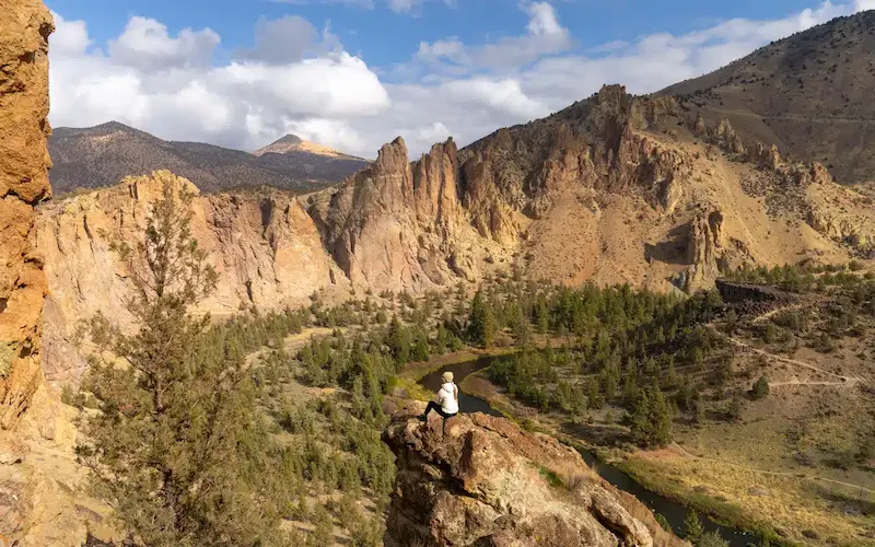
The elevation gain continues for the first half of the hike with a few stunning viewpoints along the trail. We had a quick break at the viewpoint as shown below on the picture. With a stunning view over the Smith Rock Valley and the Crooked River that carved its way through the canyon it’s worth a photo spot.

After this viewpoint it’s just a few more meters uphill before you reach the summit ridge. Make sure to take in the views from the valley as you will soon leave them behind you once you get to the ridge line. The trail will then naturally wind to the other side of the ridge.

Misery Ridge Summit Viewpoint
The ridge line of Misery Ridge is a huge flat area. There are plenty of spots and big boulders to have a break and take in the views. On a clear day, the views stretch across the high desert, to Oregon’s most iconic peaks including Mount Bachelor, Mount Jefferson, the Three Sisters, and sometimes even Mount Hood!

Just keep following the trail to make your way down along the other side of the ridge. You will now pass the iconic Monkey Face Rock, popular with rock climbers. These are the final steep switchbacks leading down until you reach the riverbank where the trail flattens out. This is the junction of the Mesa Verde Trail where you can choose to continue along the River Trail or hike the same way back. Of course, we highly recommend continuing along the River Trail as you will see new perspectives of Smith Rock Park and it’s an easy hike back to the car park.

Back via the River Trail
From the Mesa Verde trail junction, the trail continues to gradually descend. Once you’ve made it to the River Trail the path stays flat and is basically a very nice stroll along the riverbank. There are plenty of beautiful views along the way, especially the last part! You are now on the valley floor, and looking up to the rock spires is impressive!


We loved this part of the hike along the riverbank. And if you don’t fancy to hike the incline along the Misery Ridge Trail, then walking the River Trail is a fantastic alternative. In all honesty, the views looking up the rock formations might be even more impressive than from the summit!

We also loved this part along the river where rock climbers are practicing their skills. And on a calm day, you can see the beautiful reflection in the river of one of the rock formations. A stunning photo spot if you ask us!

Smith Rock State Park Entrance Fee
- Buy a $5 day pass at the fee station machines. All park users of Smith Rock State Park must buy a $ 5-day pass. You can find self-serve fee station machines at various locations in the parking lot. Only credit cards are accepted.
- America the Beautiful Park Pass is NOT accepted because this is State Park. The Park Manager will check cars throughout the day, so make sure to put your Day Pass ticket clearly on the dashboard. Don’t bring it with you when exploring the park. You can always go inside the Visitor Center for further questions.
Smith Rock State Park is a day-use area so the opening times are from dawn to dusk.
What is the history of Smith Rock State Park?
Smith Rock State Park in Central Oregon owes its formation to volcanic activity that originated around 30 million years ago. Due to a series of super-volcanic eruptions coming from the Cascade Range Mountains, massive amounts of volcanic ash, lava and other volcanic debris created the landscape with its volcanic features. Over time, these deposits solidified into the distinctive basalt rock formations visible in the park today.


Wildlife in Smith Rock State Park
If you wonder ‘What animals live in Smith Rock State Park?’ then you will be surprised by the variety of wildlife in the park. Common sightings include Golden Eagles soaring in the skies above the park. The Crooked River that cuts through the landscape supports a diverse ecosystem, and you might spot Mule Deer, River Otter, and Beavers along its banks. Birdwatchers can enjoy the presence of numerous bird species, including Red-Tailed Hawks, Cliff Swallows, Prairie Falcons and the occasional Bald Eagle. There are also plenty of small mammals residing in the park such as rabbits, ground squirrels, and a variety of reptiles.
More USA travel inspiration
I hope you enjoyed this complete guide about the Misery Ridge Trail in Smith Rock State Park. For more USA travel inspiration, head over to our other guides.
Oregon
15 stunning Oregon hikes with waterfalls
How to visit the Painted Hills in Oregon
Trail of Ten Falls in Silver State Park Oregon
Smith Rock State Park visitor’s guide
How to visit the Natural Bridges in Oregon
Washington
15 best hikes in Mount Rainier National Park
Skyline Trail in Mount Rainier National Park
New York City
30 best things to do in NYC at night – The Complete Guide
20 Best Viewpoints in NYC – The Complete Guide
Best places to stay in NYC – The Ultimate Guide


This post may contain affiliate links
We hope this guide will help you plan your travels! If you consider booking your accommodation, tours or rental car via our affiliate links, you support this blog because we earn a small commission at no additional cost to you!