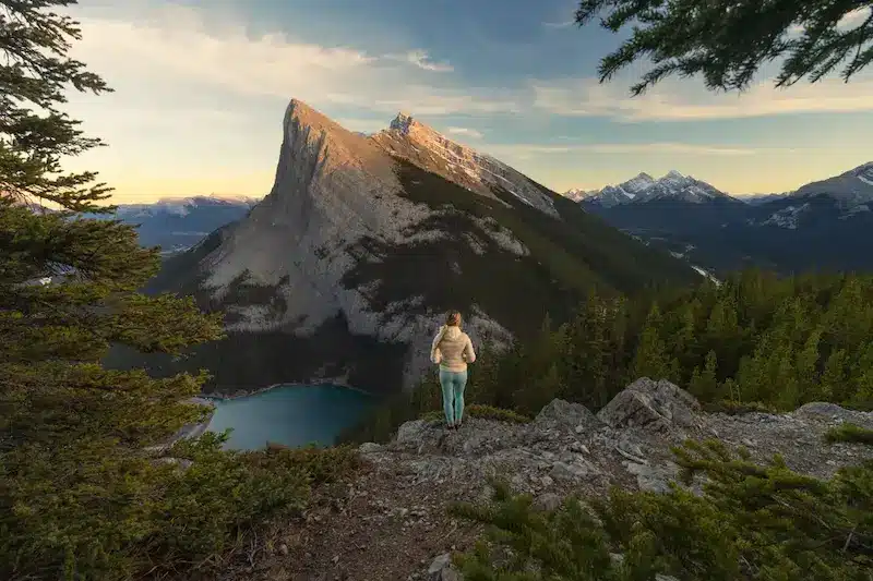
Spectacular East End of Rundle (EEOR) hike in Canmore
East End of Rundle hike in Canmore is one of the best Kananaskis hikes. The beautiful but challenging trail offers spectacular views of Ha Ling Peak, Bow Valley and Spray Valley. With the trailhead being closely located to downtown Canmore, EEOR hike (Eeyore as locals say) is a great day adventure for the experienced hiker. The technical terrain of EEOR trail includes very steep, rocky sections and scree slopes. And with only 3 kilometer one way to the summit at 2,545m (8,350 ft) height, you gain 880 meters of elevation. This means it’s a very steep trail from the beginning, so be prepared! Bring your hiking poles, more than enough water and of course proper hiking footwear. Find here in this complete guide everything you need to know before hiking East End of Rundle in Canmore.
East End of Rundle hike statistics
Length: About 5.6km (6.6 miles) out and back to the summit. But, there are many beautiful viewpoints along the way. So if your main focus is photography, then you actually don’t have to summit for the best views! You can then stop halfway up where you’ll have stunning views over Ha Ling, Bow Valley and the Spray Lakes Reservoir. In fact, summiting EEOR may take you to a higher elevation, but the views stay pretty much the same but from a higher perspective.
Elevation gain: East End of Rundle elevation is 875 meters (2,871 feet) to the summit.
Duration: Anywhere between 3 and 6 hours, depending on your level of fitness and amount of breaks. If you choose to only go to the photo spot with views of Ha Ling Peak, you can hike there in an hour.
Difficulty: Hard and technical with lots of loose scree towards the summit. But if you only go until the Ha Ling Peak viewpoint, you will save yourself from the hardest part.
East End of Rundle Trailhead
With a Conservation Pass you are allowed to park either at Whiteman’s Pond or the main Ha Ling parking lot at Goat Creek. Take note that the main parking at Ha Ling Peak trailhead is gated parking with day-use hours from 7 AM until 11 PM. So if you plan on hiking for sunrise or staying up the mountain for astrophotography, you need to park your car at Whiteman’s Pond.
The EEOR trailhead might not be the most obvious. There are no signs pointing you in the right direction. But you have to keep your eyes out for the two power poles along the road where a worn trail takes you up EEOR. AllTrails also gives a good indication of where the trailhead is. See our picture below for some visual support.

How hard is East End of the Rundle hike?
The East End of Rundle (EEOR) hike is a challenging and technical hike. Only suitable for experienced hikers as it involves a steep ascent with rocky and sometimes slippery terrain. Make sure to be prepared with proper hiking footwear, hiking poles, good physical fitness and careful navigation when tackling this trail.

What is the best time to hike East End of the Rundle?
The best time to hike EEOR is during the summer and autumn months when the trail is snow-free and most accessible. But because the trail receives plenty of sunlight, you might be able to do EEOR hike even in early May when the snow has melted away.
In terms of the best time of the day to hike East End of the Rundle I would advice starting either in the morning or a few hours before sunset. Especially if you’re into photography. Because in that case you can capture the stunning golden light of sunset that touches Ha Ling Peak.
Going for sunrise is something I would personally only advise to people who know the trail. Otherwise it is easy to get lost.

How long does it take to hike East End of the Rundle?
If you choose to summit East End of the Rundle mountain it will take you anywhere between 3 to 6 hours. If your priority is to find the photo spot, you can hike up in an hour, which is halfway up to the summit.
East End of the Rundle trail description
The first part of the trail through the forest is easy to follow and pretty steep straight away. You have to navigate over tree roots which takes about 30 minutes before you get out of the main part of the thicker forest.
This is probably the least enjoyable part of the trip as you’re climbing while being stuck in the trees. But don’t worry! You’ll emerge from the tree line in half an hour and then you can start to enjoy the view all the way until the summit. If you can plan on going to the summit of course!

After you get out of the thick forest, the trail becomes rocky and a bit harder to read, so you really need to pay attention. There are many different paths that climb along the ridge but no particular branch is better than any other.
If you generally keep to the right you can enjoy a less obstructed view while staying on the left side might provide a slightly easier and more direct route up the ridge.

Ha Ling Peak Viewpoint Sunset Photography
Our main priority was photography, so we choose to hike up before sunset to get to a stunning viewpoint before the golden light would come. We saw pictures of East End of the Rundle Summit and didn’t think there were many epic photography opportunities there. From the summit, you look down into the valley with the peaks in the distance. While at the halfway viewpoint you have a stunning photo spot facing Ha Ling Peak with the turquoise lake of the reservoir beneath.


After an amazing sunset we headed back down to the car. It only took us about 45 minutes to descend as it was much easier to follow the trail back down. Make sure to bring a headlamp if you plan on staying until sunset like we did.

Things to know before you hike East End of the Rundle
There are a few important things you need to know before hiking EEOR.
- Download the offline map on Alltrails to avoid getting lost as several trails are going up and down.
- Carry bear spray and know how to use it!
- Buy a Conservation Pass which is required to park at provincial parks and public use lands in the Kananaskis Country and Bow Valley region.
- Bring your hiking poles, you definitely need them.
- Check the weather forecast and read recent reviews of other hikers on Alltrails.
Best tours in and around Canmore
Where to stay in Canmore
Canmore is nestled in the heart of the Canadian Rockies with easy access to the iconic Banff National Park and Kananaskis country. The stunning mountain landscapes and pristine wilderness offer countless opportunities for outdoor activities and photography. While Banff is a well-established tourist destination with various amenities and tour operators, Canmore has a more relaxed and less touristy ambiance. We really enjoyed staying in Canmore and loved the wide range of accommodation options. From comfortable hotels to cozy lodges and vacation rentals, here are the best places to stay in Canmore.
Coast Canmore Hotel
The spacious and newly refurbished rooms of Coast Canmore have stunning views of the surrounding mountains. With comfy big beds, it is the perfect place to relax after a day of exploring. With an on-site restaurant and bar, indoor pool and meeting rooms, Coast Canmore has a great price quality ratio.
→ Check here current availability and prices for Coast Canmore

Other amazing Kananaskis hikes
There are plenty of other amazing hikes in Kananaskis Country Provincial Park. We did quite some research and can recommend the following epic hikes.
Smutwood Peak
Smutwood Peak is one of the most beautiful hikes in Kananaskis. The 18 km out-and-back trail with almost 1000 meters of incline isn’t for the beginner hikers. But the views are extraordinary with the sharp Mount Birdwood and Birdwood Lakes as the centre of attention. The trail takes you through a stunning alpine meadow up Smutwood Pass where the last part towards the summit includes a bit of scrambling.
Read in our complete guide everything about Smutwood Peak hike

Chester Lake
Chester Lake is a 9 km (5.8-mile) return hike following a wide gravel track through the forest which opens up in a beautiful alpine meadow that leads to the lake. With only 315 meter (1,033 feet) elevation gain it is a perfect family-friendly Kananaskis hike. The picturesque alpine basin of Chester Lake reflects the rugged beauty of the mountains that surround it which makes it a perfect place to relax and capture amazing landscape photos. The area around the lake is big and offers plenty of space for people to sit down and picnic. Remember, pack in what you pack out.
Ha Ling Peak
Ha Ling Peak is the most popular hike of Kananaskis and is closely located to Canmore. Therefore you can expect Ha Ling Peak to be a busy day hike. The 7.8 km (4.6-mile) round trip gains 750 meters on the way to the summit. This means it’s quite a strenuous hike. The 360-degree views from the summit overlook the town of Canmore, Rocky mountains and Spray Valley. Because Ha Ling Peak is facing east, it is a great sunrise hike as it can also be easily accessed from the town of Canmore.
Conservation Pass
To park at provincial parks and public use lands in the Kananaskis Country and Bow Valley region, a Conservation pass is mandatory. Two options are available for purchase: a daily pass or a yearly pass. Regardless of the number of passengers, only one pass per vehicle is needed. If you enter on foot, horse, or bike, there is no fee.
For additional details on the pass, including how and where to purchase it, visit the Kananaskis Conservation Pass website.
Where to stay near East End of Rundle Trail
The nearest town to Chester Lake is Canmore. It offers a range of facilities and accommodation choices, making it the most convenient option. However, one drawback we experienced during our stay in Canmore was the persistent sound of train horns echoing throughout the town, both day and night.
For a more quiet and off-the-beaten-path experience I highly recommend Kananaskis Village which is only 50 minutes away from Chester Lake. We stayed in Kananaskis Mountain Lodge which is a stunning luxury accommodation with beautiful rooms. The only downside is that this village doesn’t have as many facilities as Canmore. But it’s a fantastic quiet stay.
If you want to stay inside Spray Valley Provincial Park then the only accommodation option is Mount Engadine Lodge. This is the perfect option if you want to do more hikes in Kananaskis.
Coast Canmore Hotel
The spacious and newly refurbished rooms of Coast Canmore have stunning views of the surrounding mountains. With comfy big beds, it is the perfect place to relax after a day of exploring. With an on-site restaurant and bar, indoor pool and meeting rooms, Coast Canmore has a great price-quality ratio.
We really enjoyed staying in Coast Canmore Hotel, especially the views on Ha Ling Peak from bed!
→ Check here current availability and prices for Coast Canmore
Kananaskis Mountain Lodge – Autograph Collection
Kananaskis Mountain Lodge is a beautiful 4-star resort nestled in the mountains. With 5 on-site restaurants, a full-service spa, an indoor heated pool and stunning walking trails right outside of the property, Kananaskis Mountain Lodge is the perfect place to unwind after a day of exploring. We loved the spacious and cozy rooms, extensive breakfast and free S’mores by the campfire at night!
→ Check here current prices and availability for Kananaskis Mountain Lodge


Mount Engadine Lodge in Spray Valley Provincial Park
Mount Engadine Lodge is the only accommodation in Spray Valley Provincial Park. Surrounded by breathtaking mountain peaks, this is truly a unique, off-the-beaten-path stay. With all the best Kananaskis hikes at your doorstep, staying at Mount Engadine Lodge provides you with plenty of outdoor activities. With their onsite bar and restaurant and all-inclusive meals, you don’t have to worry about anything else after booking your mountain view room or glamping tent at Mount Engadine Lodge.
→ Check here current prices and availability for Mount Engadine Lodge

More Canada travel inspiration
I hope you enjoyed this complete guide about the Larch Valley hike in Banff National Park. For more travel inspiration about British Columbia and Alberta, head over to our other Canada travel guides. See below our Canada guides per National Park and area for more travel inspiration.
Read here our incredibly extensive guide about RVing in Canada

Kananaskis
Smutwood Peak hike – Complete Guide
Chester Lake hike – Complete Guide
Banff National Park
Larch Valley hike – Complete Hiking Guide
Plain of the Six Glaciers Trail – Complete Hiking Guide
Parker Ridge Trail – Complete Hiking Guide
Horse riding experience in Banff National Park
Jasper National Park
Mount Edith Cavell hike – The Complete Guide
Kootenay National Park
Floe Lake hike – Complete Guide
British Columbia
How to hike the epic Panorama Ridge in Garibaldi Provincial Park
Joffre Lakes hike – Complete Hiking Guide
St Marks Summit hike Vancouver


This post may contain affiliate links
We hope this guide will help you plan your travels! If you consider booking your accommodation, tours or rental car via our affiliate links, you support this blog because we earn a small commission at no additional cost to you!