Hiking Guide to the Epic Skyline Trail Mount Rainier
The Skyline trail in Mount Rainier National Park Washington is a stunning day hike with spectacular, open views. The well-maintained trail takes you along several beautiful viewpoints on Mount Rainier with unique perspectives of Rainier’s glaciers. If you choose to hike the loop trail, you’ll pass diverse landscapes such as alpine meadows, the beautiful Paradise Valley and Myrtle Falls with Mount Rainier as the backdrop. The Skyline Loop Trail is one of the most popular hikes in the Mount Rainier National Park, and that’s for a good reason! Lace up your hiking shoes and get ready for this stunning Mount Rainier hike.
Skyline trail Mount Rainier hiking stats
Distance: 10km / 6.2 miles
Elevation gain: 545 meters / 1,788 ft
Difficulty: Moderate
Duration: 3 – 4.5 hours
Where is the Skyline trail in Mount Rainier National Park located?
The Skyline trail in Mount Rainier National Park is located in the Paradise area where you can find a big parking lot at the Jackson Visitor Center.
Mount Rainier National Park consists of five developed areas, known as Longmire, Paradise, Ohanapecosh, Sunrise, and Carbon River & Mowich. Both the Sunrise and Paradise area are most developed and a popular base to explore the stunning Mount Rainier hikes.

Entrance fee Mount Rainier National Park
To enter Mount Rainier National Park you need to pay an entrance fee. You can either purchase the entrance pass upfront online or buy your entrance pass at the kiosk of the National Park entrance. This is a cashless payment, so make sure to bring your card.
The entrance fee for one vehicle and a maximum of 15 passengers for seven consecutive days is $30. There are no cheaper day tickets available.
If you plan to visit three or more US National Parks, then the America the Beautiful National Park Pass for $80 is recommended.
Where do you park for the Skyline Loop Trail?
There is a huge parking lot and overflow parking at the Jackson Visitor Center and Paradise ranger station where the Skyline trailhead is located. This is where you start the hike. You can choose to hike the Skyline trail clockwise or anti-clockwise. More about that later!
How long is the Skyline Trail?
When hiking the Skyline Trail Loop it is a 10 km / 6.2 miles hike with around 540 meters / 1,780ft incline.
How long does it take to hike Skyline Trail at Mt. Rainier?
It takes an average of 3 – 4.5 hours to complete the Skyline Loop Trail. Going only to Panorama Point and returning the same way will take about 2 hours in total.

Is the Skyline Trail difficult to hike?
While this is always a slightly personal opinion because not everyone has the same experience or fitness level, I would say that the Skyline Trail is a moderate hike. The incline is gradual and there are no technical parts. You just need your hiking shoes with good grip, because at some parts there is a bit of loose scree.
Doing the Skyline Trail clockwise, you will walk the first part on a paved path which was quite surprising to us. It honestly does take away the ‘raw’ vibes of a National Park, but is of course easy to walk on. Further into the hike, you will get on a dirt path and there is a rocky section that might feel slippery when descending. I’ve seen people wearing normal shoes with flat soles doing this hike, and they had a hard time at the loose scree.

Hiking the Skyline Trail clockwise or counter clockwise?
The Skyline Trail Loop can be done in several ways. We did the hike clockwise and were happy we chose it this way. I will explain why.
First of all, the views on Mount Rainier are much better doing the Skyline Trail clockwise. Right from the start you’ll have beautiful views on Mount Rainier. Only when you’re on the second half of the hike, you’ll have Mt Rainier in your back.
Doing the Skyline Trail counter clockwise, you will first pass Myrtle Falls with Mt Rainier views, but then the mountain quickly disappears behind a hill. You will then only see the best Mt Rainier views from Panorama Point before descending and having the mountain in your back.
Take into consideration that clouds often come in the morning and cover the mountain, it would be a pity if you can’t view Mount Rainier from the best viewpoints, that come early along the clockwise Skyline Trail route.
If you are short in time you can also hike the Skyline Trail one way. Most people then hike to Panorama Point and turn around to head back the same way they came.

What is the best time to hike the Skyline Trail Mount Rainier?
The best time to hike the Skyline Trail is in late spring, summer, and fall. During the summer, the meadows are full of wildflowers which gives a stunning view. However, the trail is very exposed with little shade. So in the summer months, it can get really hot.
In autumn, the Skyline Trail bursts again in colors, but now from the shrubs that turn red, yellow and orange. It’s a wonderful sight, we loved hiking the trail in this season and it was also not too hot!

You can hike the Skyline Trail in winter with snow, however you will need either snowshoes or spikes to get enough grip.
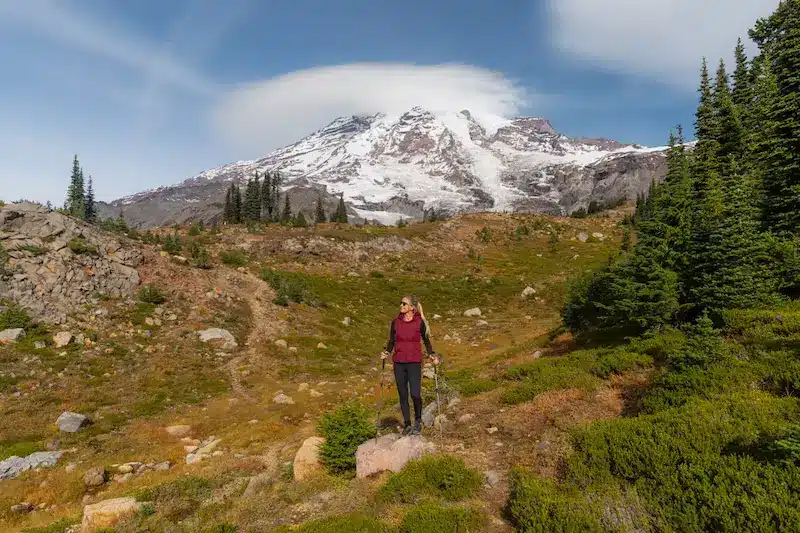
Skyline Loop Trail description
The Skyline trail is very easy to follow with clear signs along the way. The first part of the clockwise trail is paved and takes you along a scenic river with stunning Mount Rainier views.
The views on Mount Rainier are impressive, it’s just so nice to have these breathtaking views throughout a big part of the hike!

There are various viewpoints along the way, and also some side tracks that lead to a closer look on the Mount Rainier glaciers.

Making your way gradually up to Panorama Point, you will see more and more of the surrounding mountain ranges. On a clear day, you might even see Mount Hood in the distance!

Panorama Point
It’s all in the name! Panorama Point offers an incredible, panoramic view. It is the highest point of the Skyline Trail. On a clear day, you can see Mount Adams and Mt. St. Helens in Washington and Mount Hood in Oregon.


This is also the point where you are super close to Mount Rainier that you might even hear the ice cracking!

Shortcut via Golden Gate Trail
After Panorama Point it’s time to head further along the upper part of the Skyline Trail. This is also the point where Mount Rainier will be in your back when hiking clockwise. You will notice that the path changes from dirt to rocky terrain as there is a huge pile of rubble that you have to cross. But the path will always be clearly visible.


Then you will see an intersection, where you can either continue along the official Skyline Trail, or take the shortcut which is over the Golden Gate Trail. This is a slightly shorter route, and you will honestly not miss a lot if you don’t continue over the Skyline Trail.

Here you will understand what I wrote earlier, about Mount Rainier not being visible if you hike the Skyline Trail counter clockwise.
Continue to Myrtle Falls
As soon as the path changes into a paved path again, it is a sign that you are almost at Myrtle Falls. You will pass the bridge over Myrtle Falls, but from the Myrtle Falls viewpoint, you’ll have an impressive view with Mount Rainier in the backdrop. From here it is only a short walk back to the car park.

Where to stay in Mount Rainier National Park
Mount Rainier National Park has limited accommodation options, with Paradise Inn, the National Park Inn at Longmire, and the Paradise Village Lodge being the best options inside the National Park.
If you don’t mind driving 40 minutes to the Visitors Center, then staying in the nearby town of Ashford is the perfect gateway community near Mount Rainier National Park. Ashford offers a range of accommodations, including cabins and lodges, providing a rustic yet comfortable atmosphere.
More USA Washington and Oregon inspiration
I hope you enjoyed our complete guide about the Skyline Trail in Mount Rainier National Park. Head over to our other US guides for more Washington state and Oregon travel inspiration.


This post may contain affiliate links
We hope this guide will help you plan your travels! If you consider booking your accommodation, tours or rental car via our affiliate links, you support this blog because we earn a small commission at no additional cost to you!